2GIS: Map, Navigation, Tracker app for iPhone and iPad
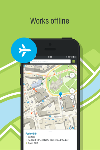
2GIS is a detailed directory with city maps and a navigator for car drivers and pedestrians. Use it online or download the city map to your device to never get lost without the internet.
With 2GIS navigation, you will feel at home even in an unfamiliar place:
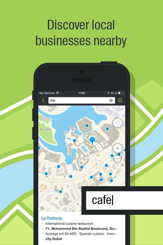
— easily find the address, company, phone number, working hours, goods or services;
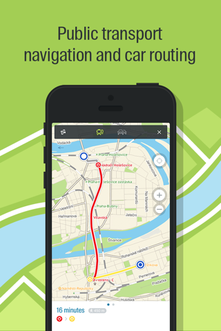
— find out how to get there by car, bus, metro, or follow the navigator on foot;
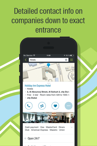
— find an entrance to a company, or an entrance to a building.
All about the buildings. 2GIS shows addresses, entrances, and postal codes.
Detailed directory. 2GIS knows phone numbers, working hours, social networks, websites, and entrance locations. Users add photos of companies and write reviews.
Accurate map. Locate districts, buildings, streets, bus stops, metro stations, gas stations, sports grounds, and other objects in 2GIS.
Navigator. Considers real-time traffic jams, road signs, traffic cameras, toll and unpaved roads, builds routes between cities and through several points. There is also a free app for CarPlay.
Road events. Reports of accidents, blocked streets, and traffic police cameras, user comments — everything is right on the map.
Friends on the map. Now 2GIS shows real-time geolocation of your friends. You decide who to add as friends and who will see your geoposition. Manage your visibility in the settings.
Public transport. 2GIS knows the timetable and online routes of public transport.
Walking routes. Pedestrian navigator paves the way wherever you can go on foot. Works in the background, supports voice guidance. Path search for pedestrians operates in 91 cities.
Travel guide. City guides: find out about the main attractions, places with Wi-Fi, and more.
Goods. 2GIS finds construction products and tires from offline stores. It helps to find out the availability of goods and compare prices in stores for the best deals.
Navigator for trucks. Cargo navigator gets directions for trucks considering the individual characteristics of vehicles and cargo.
The Apple Watch companion app conveys a map and a route created using your phone on your watch screen, and also shows your current location. Vibration will alert you when you need to turn. The Friends on the map widget on the main screen will keep you informed of your loved ones whereabouts.
Support: [email protected]
Pros and cons of 2GIS: Map, Navigation, Tracker app for iPhone and iPad
2GIS: Map, Navigation, Tracker app good for
As a bicycle lover, it would be great to use the app for route planification in Moscow. Add this feature please!!!
I used this App during my holiday and Sightseeingtour in Dubai.
Always helped me to find the next station and to plan a route.
It is fully working offline, you do not need an Internet Connection for this.
The offline map is also very good and is coming with a lot of POI and information.
I love this app, it has saved my life! I just moved to a new country and this app is the only reason I have been able to go anywhere, especially on the bus! Its works without internet so I can use it on the bus to see how close to my stop we are getting. Or find a new route if I decide I want to go somewhere else before go home.
I have 2 complaints about it. If I switch apps (even answering a phone call) or let the screen lock, the route gets erased and I have to start over. That almost got me lost once while going to the outskirts of the city!
And, I cant save a place to my favorites with a custom title, the address is saved, which for me is difficult because its in a foreign language I barely speak. And after a few saved addresses I begin to forget which one is which.
I really like the app and I use it all the time despite those minor issues. One last thing, it would be great to be able to select a bus route and see where it goes instead of only seeing the route numbers that take you to a specific place on the map. :D
You dont need an internet connection with this so thats awesome for travelers.
My favorite program in abroad.
Super application,but need review options and uploading more cities
If you could mark which streets have been closed due to road work or flooding, that would be very helpful.
Some bad moments
Until updated. Cant get it to work anymore. Freezing all the time. Unfortunately.
Please ıt doesnt show night transportatıon and i would like to see in every sıtuatıon even ıf ıt ıs 3 hour how it is by walking please put these features
Seriously disappointed. Please return the walking route option to the app.
Oh, so it only has Russian cities. I will delete this app now.
I miss the older version. The new updates made the app extremely uncomfortable to use. Its annoying if an app lags when you really have to use it.
Awesome app! Extremely good job guys! Thank you for useful application.
Usually 2GIS: Map, Navigation, Tracker iOS app used & searched for
2gis,
магазин,
correos,
2gis – offline maps,
maps me,
maps.me - offline maps,
wifi maps,
directions app,
mapsme,
directions,
map me,
offline maps & navigation,
offline navigation,
the dubai mall,
direction,
dubai metro,
gps offline,
offline maps,
wifi map llc,
dubai map,
dubai mall map,
and other. So, download free 2GIS: Map, Navigation, Tracker .ipa to run this nice iOS application on iPhone and iPad.